Firefighters Gain Upper Hand
July 27, 2021
TAMARACK Firefighters Gain the Upper Hand
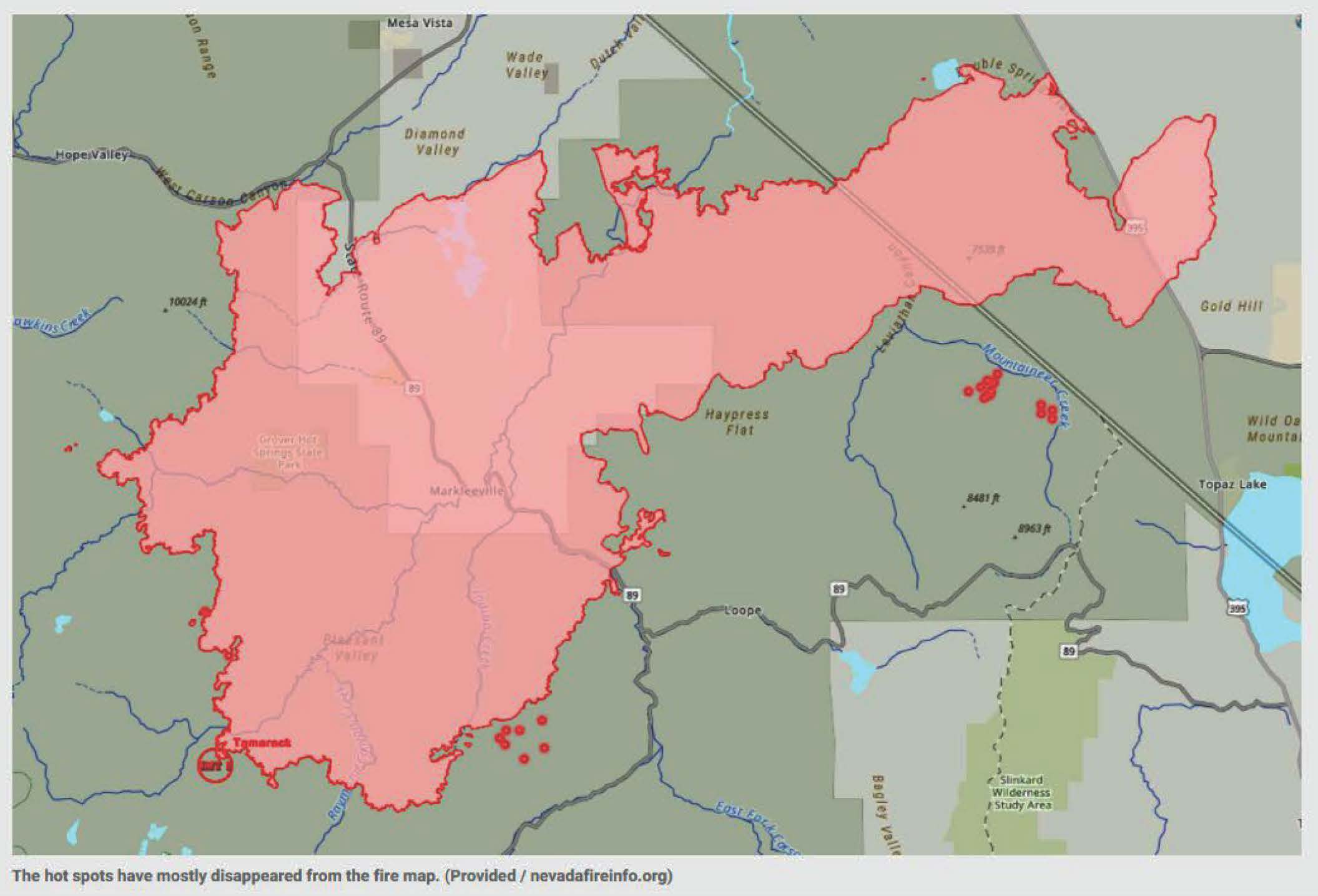
Mandatory evacuations have been lifted for many and highways have been reopened as the Tamarack Fire has been more than half way contained now that the firefighters have gained the upper hand. The fire that destroyed dozens of structures and forced thousands from their homes looks like it’s winding down as firefighters gain the upper hand. The fire is at 68,103 acres and 54% contained as of Tuesday morning according to the InciWeb Incident Information System.
California State Route 88 is open and mandatory evacuations have been lifted for Blue Lakes Road and Upper and Lower Blue Lakes Campground in Hope Valley. California State Route 89 remains closed from the junction of SR 88 to U.S. Highway 395. California State Route 4 remains closed at the junction of SR 89 to Ebbetts Pass. Mandatory evacuations are still in place for residents in the Highway 4 corridor from SR 89 to Ebbetts Pass.
Residents must have proof of residence (ID or utility bill) to bypass the State Route 89 road closure. State Route 89 will remain closed and only accessible for residents in the area. Residents are recommended to use extreme caution when re-entering the area. Officials said additional evacuations are possible due to fire activity.
Incident Overview
The Tamarack Fire started as a lightning strike in the Mokelumne Wilderness on a rocky ridgetop with sparse fuels and natural barriers to fire spread. Friday, July 16 high winds caused rapid downslope fire spread. With this change in the fire, resources were quickly dispatched to the site. Additional resources were ordered, including very Large Air Tankers (VLAT), Single Engine Airtankers (SEATS) and helicopters.
The Type 2 Great Basin Incident Management Team #3 assumed command of the fire on Sunday, July 18 at 6 a.m. transitioning to the Rocky Mountain Type 1 Incident Management Team on Tuesday, July 20. Many Federal, State, and Local government agencies as well as organizations and businesses are cooperating to make progress on the fire.
This is a full suppression fire. Public and Firefighter safety is the number one priority. Minimizing impacts to local communities, private property and structures, natural resources, highway corridors, and recreation improvements are key considerations. Our intent is to keep you fully informed on the fire’s activities and our suppression efforts as the incident progresses.
The Rocky Mountain Type 1 Incident Management Team has produced an interactive map so the public can see the Tamarack Fire location in relation to their address. Please click here Tamarack Fire 2021 Interactive Map or use this url https://bit.ly/TamarackInteractiveMap
For the latest information on road closures, visit: QuickMap (ca.gov) and https://roads.dot.ca.gov/
Evacuation related information can be found by clicking on the Announcements section above or below.
Additional information can be found from these sources:
Tamarack Fire Information Facebook: https://www.facebook.com/tamarackfireinfo
Twitter: @Tamarack_Fire
Videos of the Daily Operational Briefings for the public and future community meetings will be posted on the Tamarack Wildfire Official Information YouTubewebsite at: https://bit.ly/TamarackVideo
If using a cell phone to view this page, you can click on the words directly below to view those topics.
MLS Search


Listing Watch
Sign up to receive instant email notifications when properties meeting your search criteria come on the market.